For "Travel Tuesday":
Around Big Bend National Park, TX, are some other interesting places:
LAJITAS, TX
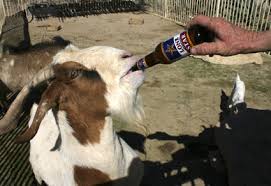
"For many years the mayor of Lajitas was Clay Henry III, a "beer-drinking" goat. After 2 replacements of the original Clay Henry, the trading post and stable where the mayor lived is now closed and the goat no longer resides there.
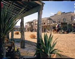
Lajitas is on the western edge of Big Bend National Park in southwestern Brewster County. It is at an altitude of 2,200 feet on a bluff overlooking the Rio Grande at the San Carlos ford of the old Comanche Trail, in the northern part of the Chihuahuan Desert and at the southern extreme of the Rocky Mountains.
The name Lajitas is Spanish for "little flat rocks" and refers to the Boquillas flagstone of the area. The region was inhabited by Mexican Indians for many years. They were driven from the area by the Apaches and later by the Comanches during the eighteenth and nineteenth centuries. Anglo-Americans first arrived in the mid-1800s. In 1852 Lt. William H. Emory visited the site.
In the late 1890s quicksilver was discovered near Terlingua, eleven miles from Lajitas, and a rapid influx of people followed (see MERCURY MINING). At the same time a number of cattle ranches and mining enterprises appeared in northern Chihuahua and Coahuila. These activities increased commerce across the Rio Grande into Texas; consequently, by 1900 Lajitas was designated a substation port of entry. Farming along the narrow floodplain of the river served to bring in more families, and by 1912 the town had a store, a saloon, a school with fifty pupils, and a customhouse. The crossing, a smooth rock bottom all the way across the river, was the best between Del Rio and El Paso.
H. W. McGuirk, the leading citizen of Lajitas from 1902 to 1917, operated the store-saloon, farmed, and helped manage the Terlingua Mining Company. He also funded the construction of a church and a school. Lajitas officially had a post office as early as 1901, but it did not become operational until McGuirk petitioned for its reestablishment in 1904. It was closed temporarily in 1910, reopened in 1916, and closed permanently in 1939. McGuirk sold his landholdings around Lajitas to Thomas V. Skaggs, who continued farming. Skaggs also became successful in a candelilla wax business, the Lajitas Wax Company. In 1916 the interruption of commerce by Francisco (Pancho) Villa's bandits brought Gen. John J. Pershing's troops to Lajitas, where they established a major cavalry post. In the 1980s a motel stood on the actual foundations of the post.
The Lajitas property continued to change hands and in 1949 was bought by Rex Ivey, Jr., who hand dug a well and installed a generator for the area's first electric lights. Due to the closing of the Terlingua quicksilver mines, the number of residents in Lajitas had dwindled to four. In 1977 Ivey sold part of the Lajitas area to Houston entrepreneur Walter M. Mischer, of Mischer Corporation; Mischer had begun development and restoration of the community in 1976, under the name of the corporation's subsidiary, Arrow Development Company.
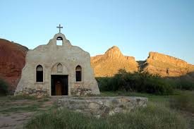
In the mid-1980s Lajitas was a resort town with fifty residents and fifteen businesses. The old church had been restored, and there were three motels, a hotel, a restaurant, a golf course, a swimming pool, an RV park, and an airstrip. Just east of town was the Lajitas Museum, a large, modern building containing artifacts of the Big Bend area. The old trading post remained open. In 1990 the population was still reported as fifty.
In 1995 the Big Bend area was becoming increasingly popular as a site for movie making. Lajitas, according to one producer, was just about the only place where "you can shoot 360 degrees," since Santa Fe and Sedona were "used up."
At that time a TV miniseries, Streets of Laredo, starring James Garner, was being filmed in Lajitas. In 2000 the population was seventy-five."
_____________

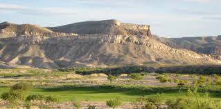
The rugged country of the Lajitas area.
_____________
L A J I T A S, ![]() T E X A S
T E X A S
"Lajitas is a resort town located just off Big Bend National Park between Big Bend Ranch State Park and the Rio Grande River. Across the Rio Grande on the Mexican side is Paso Lajitas, which used to be accessed by an informal border crossing but that has been closed. Lajitas used to be a favorite destination for visiting the big bend area of Texas but since the airport has moved away, the border crossing has closed, the beer-drinking goat died, and room prices have tripled, we can't think of a reason to go there. We prefer to visit the new Big Bend Ranch State Park."
____________
Big Bend Ranch State Park
"Big Bend Ranch is located adjacent to Big Bend National Park and shares the national park's Chihuahuan Desert ecosystem. However, in one significant aspect the state park is managed very differently from the nearby national park, as the state park encompasses a network of cattle ranches operated according to the principle of the open range.
A herd of longhorn cattle is based here, and there is a semi-annual longhorn roundup.
The Big Bend Ranch manages 23 miles (37 km) of frontage along the Rio Grande river, and river rafting is popular here. Away from the river, visitors can hike, backpack, go horseback riding or enjoy mountain biking in the Big Bend Ranch's substantial backcountry. The park is open year round and an admission fee is charged."
____________
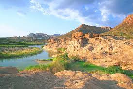
"Big Bend Ranch State Park, the largest state park in Texas, over 300,000 acres of Chihuahuan Desert wilderness in a remarkably rugged, remote and unpopulated setting. The park extends along the Rio Grande from southeast of Presidio to near Lajitas in both Brewster and Presidio Counties. Embracing some of the most remote and rugged terrain in the Southwest, it encompasses two mountain ranges containing ancient extinct volcanoes, precipitous canyons, and waterfalls.
The area has been a crossroads of human activities for over 11,000 years, as diverse people and cultures have been drawn by the abundant resources of the Rio Grande/Rio Bravo corridor."
______________
Big Bend Ranch State Park - Natural Features
"Big Bend Ranch State Park in Presidio and Brewster Counties between Presidio and Lajitas, Texas is in the northern Chihuahuan Desert. The park contains over 300,000 acres and has about 23 miles of river frontage along the Rio Grande, the international boundary between the U.S. and Mexico. Elevations range from about 2,350 feet along the Rio Grande to over 5,000 feet at Oso Mountain and Fresno Peak. Climate is typical of a high desert setting with hot summers, mild winters and low annual precipitation."

Aerial view of the Solitario.
"The geologic history of Big Bend Ranch ranges over 600 million years and presents a unique geologic story. Big Bend Ranch State Park contains bedrock exposures ranging from Paleozoic deep-marine sediments to tuffs, rhyolites and basalts that resulted from Tertiary igneous activity. Tectonic activity from the Marathon-Ouachita and Laramide orogenies and present day Basin-and-Range extension has created faults, folds, horsts and grabens to form the rugged terrain that characterizes the landscape. Along with these upheavals were many intrusions and several volcanoes."
Watch for radio-collared desert bighorn sheep like this ram during your stay.
"Deep layers of sedimentary and volcanic deposits between igneous layers capture water thus forming small, perched aquifers. Larger bolsons (self-drained grabens) capture larger amounts of water forming larger, though local, aquifers. These geologic controls provide Big Bend Ranch State Park with many springs despite its desert setting. The relative abundance of groundwater, riparian areas, and the Rio Grande attracted humans to the area as early as 9,000 to 10,000 years ago and, more recently, encouraged sheep, goat and cattle ranchers to settle and work the area. The Big Bend Ranch area is one of the better-watered areas of Trans-Pecos Texas."
Rock Art of Big Bend Ranch State Park
"Our region is full of traces of earlier life in the form of rock art, from Hueco Tanks in the west to Big Bend in the east. This photo comes from Big Bend Ranch State Park from a place on the main road to Sauceda Ranch."
_______________
El Solitario Newsletter:
"Each season of the year holds its own set of wonders at Big Bend Ranch State Park and draws visitors from all walks of
life: tourists, hikers, campers, naturalists, and sports enthusiasts. Photographers
love it, too. Fall and winter
are perhaps the most popular
seasons, when cool, sunny
days abound and the palette
is composed mostly of earth
tones. Springtime is marked
by the brilliance of cacti,
ocotillo and yucca erupting
into flower, a precursor of the
summer rainy season when the
desert really comes to life. No
matter the time of your visit,
you will experience stunning
landscapes and expansive
skies. Here are some ideas to
help you get the best pictures
possible during your visit."
Read the 2012, and previous newsletters here: http://www.tpwd.state.tx.us/publications/pwdpubs/media/pwd_br_p4507_1437_2012.pdf
______________
On This Day:
Gusher signals start of U.S. oil industry, Jan 10, 1901:
"On this day in 1901, a drilling derrick at Spindletop Hill near Beaumont, Texas, produces an enormous gusher of crude oil, coating the landscape for hundreds of feet and signaling the advent of the American oil industry. The geyser was discovered at a depth of over 1,000 feet, flowed at an initial rate of approximately 100,000 barrels a day and took nine days to cap. Following the discovery, petroleum, which until that time had been used in the U.S. primarily as a lubricant and in kerosene for lamps, would become the main fuel source for new inventions such as cars and airplanes; coal-powered forms of transportation including ships and trains would also convert to the liquid fuel.
Crude oil, which became the world's first trillion-dollar industry, is a natural mix of hundreds of different hydrocarbon compounds trapped in underground rock. The hydrocarbons were formed millions of years ago when tiny aquatic plants and animals died and settled on the bottoms of ancient waterways, creating a thick layer of organic material. Sediment later covered this material, putting heat and pressure on it and transforming it into the petroleum that comes out of the ground today.
In the early 1890s, Texas businessman and amateur geologist Patillo Higgins became convinced there was a large pool of oil under a salt-dome formation south of Beaumont. He and several partners established the Gladys City Oil, Gas and Manufacturing Company and made several unsuccessful drilling attempts before Higgins left the company. In 1899, Higgins leased a tract of land at Spindletop to mining engineer Anthony Lucas. The Lucas gusher blew on January 10, 1901, and ushered in the liquid fuel age. Unfortunately for Higgins, he'd lost his ownership stake by that point.
Beaumont became a "black gold" boomtown, its population tripling in three months. The town filled up with oil workers, investors, merchants and con men (leading some people to dub it "Swindletop"). Within a year, there were more than 285 actives wells at Spindletop and an estimated 500 oil and land companies operating in the area, including some that are major players today: Humble (now Exxon), the Texas Company (Texaco) and Magnolia Petroleum Company (Mobil).
Spindletop experienced a second boom starting in the mid-1920s when more oil was discovered at deeper depths. In the 1950s, Spindletop was mined for sulphur. Today, only a few oil wells still operate in the area."
_____________
Yesterday:
First modern circus is staged, Jan 9, 1768:
"On this day, Englishman Philip Astley stages the first modern circus in London.
Trick riders, acrobats, clowns, trained animals, and other familiar components of the circus have existed throughout recorded history, but it was not until the late 18th century that the modern spectacle of the circus was born. Astley, a former cavalry sergeant major, found that if he galloped in a tight circle, centrifugal force allowed him to perform seemingly impossible feats on a horse's back. He drew up a ring and on January 9, 1768, invited the public to see him wave his sword in the air while he rode with one foot on the saddle and one on the horse's head.
Astley's trick riding received such a favorable response that he soon hired other equestrians, a clown, and musicians and in 1770 built a roof over his ring and called the structure Astley's Amphitheatre. In 1772, Astley went to Versailles to perform his "daring feats of horsemanship" before King Louis XV, and he found France ripe for a permanent show of its own, which he founded in 1782. Also in 1782, a competitor in London set up shop just down the road from Astley's Amphitheatre, calling his show the "Royal Circus," after the Roman name for the circular theaters where chariot races were held. In the 19th century, the term "circus" was adopted as a generic name for this new form of entertainment. Astley, who lived until 1814, eventually established 18 other circuses in cities across Europe.
In 1792, English equestrian John Bill Ricketts opened the first American circus in Philadelphia and later opened others in New York City and Boston. President George Washington reportedly attended a Ricketts circus and sold the company a horse. Smaller traveling circuses arose in Europe in the early 19th century, visiting towns and cities that lacked elaborate permanent shows. Larger traveling tent shows evolved in the 1820s. In 1859, the Cirque Napoleon in Paris offered the first "flying trapeze" act, which remains a popular component of the modern circus.
In 1871, William Cameron Coup and showman P.T. Barnum opened an enormous circus in Brooklyn that they dubbed "The Greatest Show on Earth." Ten years later, Barnum went into business with James Anthony Bailey; the "Barnum and Bailey" circuses were so large they required simultaneous performances in three rings.
In 1884, the five Ringling brothers staged their first circus, and they soon were buying out other circus companies, including Barnum and Bailey, which they purchased in 1907. During the next three decades, the Ringling Brothers and Barnum & Bailey Combined Shows grew into the largest touring organization in the world, with hundreds of tents and an army of workers and performers. The Ringling Brothers and Barnum & Bailey downsized after World War II but continues to tour today. Canada's Cirque du Soleil, which gave an artistic sensibility to its acrobatic acts while shunning the use of animals, was an innovative circus development of the late 20th century."
____________
My Yesterday:
I was awakened by thunder before 5.30AM, and it was pouring down rain as I had my coffee and got dressed. Misty and I donned our raincoats 
Normally, Misty refuses to go out in the rain, but she doesn't mind now that she has her waterproof barn coat. We were still able to get in a short walk down at Jay's, and our hooded raingear kept us dry, except for our feet. Misty had to be guided around the enormous puddles. One could almost see the lake rising. I keep a big towel on the back seat, so Misty doesn't ruin the Puddle Jumper's 24 year old velour upholstery, which is still like new.
Jay and I worked some more on the computer area's L-shaped desk. We cut and screwed boards just inside the workshop with the big doors open to the torrential rain. We now have the corner cabinet at the right height. We also brought some Formica down from the storeroom attic, and as soon as we get both parts of the "L" shaped top completely done, we will Formica it.
Neither the heat nor AC has been on for ages, but we had to turn on the AC, it was so humid in the house. Jay wanted me to take him to town to cash a check, but I wasn't going to drive in that mess, and the road to town was flooded.
Dizzy-Dick said, "On a rainy day like today, an afternoon nap may be just the thing to do. The storms and my dogs didn't let me get a lot of sleep last night."
Misty isn't scared of storms, so she didn't wake me up, it was the thunder that did that yesterday.









5 comments:
When we were at Terlingua/Big Bend we went to Lajitas often. That was before we got our satellite internet (we got it that summer, I think). There was no free internet in Terlingua so we drove to Lajitas. The whole town was wifi! When we were there I think the town was owned by Steve Smith, at least that's what I remember. He was from Austin, I think.
I have been there, too. That whole area is a beutiful and rugged place full of interesting people.
Thank you for your comments, Sandra and DD.
I have been in that area twice, and I think the drive from Presidio following the Rio Grande River to Study Butte is breathtaking. It is listed as one of the most scenic drives in the USA.
Happy Tails, and Trails, Penny.
I hope all that rain is doing some good in your area. Sometimes in an extended drought many plants die and don't recover once the rains fall.
Thank you for your comment, Gypsy.
It is the trees which have suffered the most from the drought. Crews have been cutting down the dead trees to stop them from falling on the power lines.
Now, some are falling over due to the water sodden ground.
Happy Tails to Lady, and Happy Trails to You. Penny.
Post a Comment