For “Travel Tuesday” let’s visit Bolivar ‘Island’, which is in the TX Gulf Coast Region.
“ Home to some of the best beaches in America, the Texas Gulf Coast region draws millions of visitors to this Texas playground. Stretching some 350 miles from South Padre Island & the Rio Grande Valley, all the way to Beaumont & the Louisiana border, this region is renowned for its wildlife & natural beauty, as well as the home of America's space program. Discover the Beaches of the Texas Gulf Coast Region.”

“The Bolivar Peninsula is Beautiful and that's not a ‘Ferry’ tale!
For anyone who lives inland, there's an indescribable feeling of relaxation and freedom at the first sight of water as he or she approaches the coast." - Pat Daniels Houston Chronicle
“The Bolivar Peninsula is a narrow strip of land on the Texas Gulf Coast in the easternmost part of Galveston County. The peninsula is separated by less than three miles from Galveston Island by the channel of Bolivar Roads, the entrance from the Gulf of Mexico to Galveston Bay. Free public ferries link the Bolivar Peninsula with Galveston Island.
It stretches lazily along the Gulf of Mexico for 27 miles. At it's widest point between Crystal Beach and Caplen it's 3.5 miles wide, and at it's narrowest point in the Rollover Pass area it's 1/4 mile wide. Although classified as a peninsula, it's actually a barrier Island, and is accessible by land from a bridge over rollover pass to the mainland through southern Chambers County.
Major tourist pursuits are swimming, sunbathing, fishing, hunting, beachcombing, shell hunting and bird watching. Extending the length of the peninsula at its northwest side is the Gulf Intracoastal Waterway.
Bolivar's five residential communities include: Crystal Beach, Port Bolivar, Caplen, Gilchrist and High Island. The population more than doubles during the summer months as owners of beach homes and tourists arrive to enjoy the beach, sun, bay sunsets, fishing, relaxation and the many attractions of the Bolivar Peninsula "Island".
Whether entering the Bolivar Peninsula after an entertaining ride on a ferry or by highway from Winnie through High Island, you enter a unique and exciting world.”
______
Bolivar Peninsular. By Jerry & Gloria Quincy
“We will be leaving Galveston Island State Park tomorrow morning. We are moving only about 45 miles to a new site we found on the Bolivar Peninsula. We feel so blessed to find this site. It is right on the beach, the private owner is building his home on the property and is renting his RV space to us for a month, the cost is only $300 plus electric. It has full hook-ups and a view that is incredible. We are about to celebrate five years on the road, this is without a doubt the BEST site we have ever had.”
“We had a very short travel day today, only 45 miles from Galveston. We are now set up right on the beach in the Bolivar Peninsular. It is the BEST sites we have ever had. We watched men fish right outside our window, we saw them catch a HUGE fish. They were catching so many fish they stayed overnight and fished with a lantern. Jerry is ready to go fishing already, he has to go and buy his license tomorrow.”

Driving on the ferry...

We took the ferry to Bolivar..

Our site is right on the beach..

We watched men fishing from our couch.. awesome!
We are in paradise in our new location, I will let the pictures tell the rest of the story. More at: http://www.mytripjournal.com/travel-719990
_______
Rollover Pass.

Woo! Look at this big boy catch! Abel Garcia from Dayton Texas caught and released this 25lb black drum 2/16/2013 4pm at Rollover Pass
“Rollover Pass (also called Rollover Fish Pass) is a man-made strait that cuts through the Bolivar Peninsula and links the Gulf of Mexico with Rollover Bay and East Bay on the upper Texas coast in eastern Galveston County.
![images[3] images[3]](https://blogger.googleusercontent.com/img/b/R29vZ2xl/AVvXsEhrs90WXuhiHh3Si11BAimaB92nciAkmn78km_28ReZxOrgXAWD48WYLi1I3Wfuo0ouekeW7W5zLIBxVQfyxV2gMmeGp0zvD0KlEEzdfmMkVf8DXpyyWD94UaiZfC5g2h4BoIjnE5KcNzS-/?imgmax=800)
![images[4] images[4]](https://blogger.googleusercontent.com/img/b/R29vZ2xl/AVvXsEgZRtbeh5wV1458hjBGyreGi7U8xF0md3AO6B1cjwOm0VhHnHVXCAtFRKLIZWS223Jy40-Rvi97_he9FfKpCVjfy5bSRC0V4e4wjMSWibGrxOmZaRjj21HS2Mkj6FLpNkmBgYG8iGIShRAo/?imgmax=800)
______
GILCHRIST, TX
“Gilchrist is a resort and residential community on State Highway 87 on Bolivar Peninsula some seventeen miles east of Bolivar Point in Galveston County. The community was named for Gibb Gilchrist, who relocated and reconstructed the rail line from Port Bolivar to High Island after the 1915 hurricane had destroyed it.
Before that time the settlement in the area had been called Rollover. A post office was established at Gilchrist in 1950. A key feature of the community is the Rollover Fish Pass (or Rollover Pass), which bisects Bolivar Peninsula as well as Gilchrist and carries water between East Bay and the Gulf of Mexico. Fishing in its waters is considered among the best in Texas. Rollover Pass was a natural pass that had been closed until 1955, when it was opened by the Texas Game and Fish Commission as part of its efforts to preserve and improve fish and wildlife resources. In 1990 Gilchrist's core population was about 750, but it had significantly more residents during the summer and on holidays. Several businesses catered to permanent residents as well as to sportsmen and tourists.”
______
Rollover Pass By Jerry & Gloria Quincy
“Rollover Pass is known as one of the best fishing areas in Texas. Rollover Pass (also called Rollover Fish Pass) is a man-made strait that cuts through the Bolivar Peninsula and links the Gulf of Mexico with Rollover Bay.
Since the artificial pass was built in 1954, it has been hailed for providing easy access to no-fee, high-quality saltwater fishing - an "everyman" fishing spot where anglers lining the cut's edges or wade-fishing around its ends can enjoy tremendous success catching flounder, speckled trout, redfish, croaker, black drum and even tarpon.

I loved being able to drive right up to the fishing wall...
It also has been touted as a beneficial pathway for migration of adult and juvenile fish, shrimp and other marine life between bay and Gulf, as well as allowing tidal "flushing" of the bay. It is also a popular place for birding, which is exactly what I did while he fished. :-) I also walked the beach and picked up more shells for my shell collection. Another wonderful day on the beach.” More at: http://www.mytripjournal.com/travel-720552
______
High Island.
“High Island Texas is on a tall salt dome on Bolivar Peninsula at the extreme eastern end of Galveston County. Its thirty-eight-foot rise above sea level makes High Island the highest point on the Gulf of Mexico.”
About High Island

“Today High Island is a small town of about 450 people on the Upper Texas Coast between Galveston and the Louisiana border. It’s usually a quiet town, but each year from March through to May, thousands of enthusiastic visitors from all over the world pour into the area to enjoy the huge numbers of migrating birds that pass through on their way north to their breeding grounds.
THE HISTORY OF HIGH ISLAND
High Island was undoubtedly used by Indians for thousand of years. No archeological sites have been excavated on the island, but shell middens, pieces of black pottery and arrow points dating from as far back as 1200 A.D. have been found on Bolivar Peninsula and around Galveston Bay. These indicate the presence of hunter-gatherers who roamed the region collecting shellfish and hunting the abundant wildlife. Indians may have also visited the mineral springs that were a result of the minerals associated with the salt dome mixing with ground water, which used to exist on the “Island.”
According to the legend, the pirate Jean Lafitte and his crew sometimes had parties in the big grove of oak trees that covered the island when they cruised the coast in the early 1800’s. There are rumors that the pirates buried some of their treasure here. Although many have searched, no one has ever reported finding any trace of the pirates or their treasure.” From: http://www.birdinghighisland.com/about.htm
______
Hurricane Ike Impact on High Island, Texas September 20, 2008
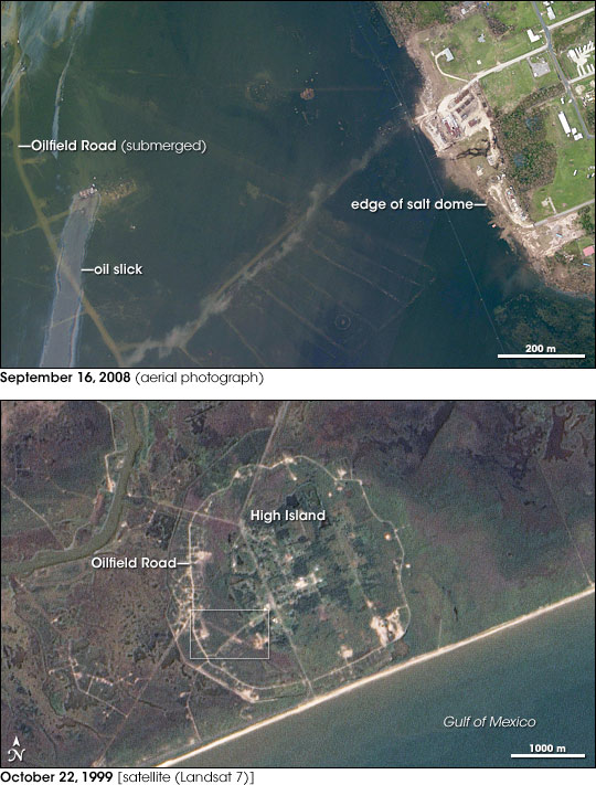
“East of Galveston, Texas, a thin barrier beach—Bolivar Peninsula—stretches along the coastline. Like Galveston, this barrier beach lay directly in the path of Hurricane Ike in September 2008. On the far eastern end of Bolivar Peninsula is High Island, so named for the salt dome that boosts the area some 11.6 meters (38 feet) above the rest of the Gulf Coast between Mobile, Alabama, to the Yucatán Peninsula.
These images show High Island before and after the destruction caused by Hurricane Ike. NASA’s Landsat 7 satellite captured the bottom image on October 22, 1999. In this image, the encircling Oilfield Road delineates High Island, which otherwise looks similar to the surrounding landscape, with its mixture of urbanized and vegetated areas. The white rectangle in this image outlines the area shown in the top image. A photographer with the U.S. National Oceanic and Atmospheric Administration (NOAA) took the top photo from an airplane on September 16, 2008. In the top image, High Island really has become an island. Off the edge of the salt dome, water has submerged the landscape, and an oil slick floats over Oilfield Road.”

More at: http://earthobservatory.nasa.gov/IOTD/view.php?id=9107
I hope you enjoyed this little tour of Bolivar Peninsular.
_______
On This Day:
Antonio de Ulloa tries to govern Louisiana, Mar 5, 1766:
“A brilliant Spanish scientist and explorer, Antonio de Ulloa's political talents prove far less impressive when he tries to take control of the formerly French territory of Louisiana.
Ulloa faced a difficult situation in Louisiana. Encompassing most of the western half of the Mississippi Valley as far north as the present-day state of Montana, Louisiana Territory was originally claimed and settled by the French. In 1763, the French transferred the territory to Spain under the terms of the Treaty of Paris, as a reward for having been an ally in the French war with England. The French colonists of Louisiana, however, had not agreed to the treaty. Many were determined to frustrate any attempt by the Spanish to assert control over their home.
This impulse to resist only strengthened when the Spanish failed to immediately dispatch a new governor for the territory, leaving the administration in the hands of the acting French Governor Philippe Aubry. After a three-year lag, the Spanish crown finally sent one of its most distinguished scientists and explorers, Antonio de Ulloa, to govern the territory.
Arriving in New Orleans on this day in 1766, Ulloa faced widespread antagonism to his rule. Before coming to Louisiana, Ulloa had led a brilliantly successfully exploration of Peru, which he publicized in the widely read book A Voyage to South America. Ulloa had also gained fame among European scientists by founding an astronomical observatory and a mineralogical laboratory. However, Ulloa's scientific accomplishments did not impress the French inhabitants of Louisiana.
For all his scientific brilliance, Ulloa proved a timid and ineffective governor. When the French troops of Louisiana refused to recognize his authority, Ulloa did not even attempt to stage a public ceremony marking the formal transfer of power to the Spanish crown. Instead, he decided to execute his orders through Aubry, the acting French governor, preserving the appearance of continued French rule. Possessed of a personality that dangerously combined shyness with arrogance, Ulloa was completely unsuited for the delicate diplomatic task of bringing the people of Louisiana under Spanish control.
Ulloa's attempts to force the French colonists to use the handful of Spanish-dominated ports in the territory further alienated his subjects, as did his refusal to honor old French promissory notes held by many of the colonists. In 1768, the French political leaders revolted, forcing Ulloa to flee to Havana, Cuba. Although subsequent Spanish officials were better able to control the French residents, Spanish control over Louisiana continued to remain tenuous. In 1800, Spain finally abandoned its claim to the territory and handed it back to the French. Three years later, Napoleon Bonaparte sold it to the United States in the Louisiana Purchase. Unlike their Spanish predecessors, the Americans eventually succeeded in winning the loyalty of the Louisianians.”
_________
Yesterday:
I had to stay here as the new wall heater was arriving, and I didn’t want to take the chance of it being stolen off my front step. So I had to postpone Satchmo’s visit to the vet for his thyroid test.
So, while I was waiting, I spent a lot of time researching the disease, symptoms and treatment. Even without the test, I know Satchmo has it. His thyroid is enlarged and he has an insatiable hunger, and even with 4-5 feedings a day, he is still begging for food. It seems to consume his life, and he isn’t a very happy kitty. Skittishness seems to be another side effect of the disease. He seems happy here, but just seems uneasy all the time. He will stand next to Misty, so he’s not worried about her. When he comes up to me, it is usually to ask for food.
I had hoped to find successful less aggressive forms of treatment, but when I joined a Yahoo group for Hyperthyroid Cats, I read so much woe, worry and distress for the cats having the conventional radiation treatments. Throwing up, diarrhea, itching, shaking, and hiding. I had found out about some holistic treatments, but I didn’t even have to post on there asking about them, someone already had. Apparently, it only works in the first stages when they aren’t showing the main symptoms. The quality of life for the cats doesn’t seem to be so great. Some of the cat ‘parents’ seemed to be selfishly prolonging their cat’s suffering.
We need to get this heater installed pronto, but Satchmo is my priority, so I am going to see if I can get him seen by a vet today.

![images[7] images[7]](https://blogger.googleusercontent.com/img/b/R29vZ2xl/AVvXsEilxo869cN7EDxYKLHUfcjbLJAOeNSGGo8X2-jk8cnoAXGNbv7bKv3swptCyDHdtn33DvLUwN9-Y4SicsZISYPOYLdNbQSpZ0Sx6TkjtbJvU8t8JIhd7dmF6cLNke9TGfKo_rEDUwhZQDWd/?imgmax=800)
![images[3] images[3]](https://blogger.googleusercontent.com/img/b/R29vZ2xl/AVvXsEhTJRcw-W-bZljBh45pAeEIrbC4V3szs-vEW3UjwZmgUxJ5zak92Kq3H4Vd0wguCwNHUpiFLVlTLI5BohNpTNyLbiaYed4PtgcncZ2-osHxtZJm0JeG8Kx4_5mysSBq3eXd42qaTl3IgdqM/?imgmax=800)
![images[6] images[6]](https://blogger.googleusercontent.com/img/b/R29vZ2xl/AVvXsEiO73h0C4SJB6ZF5H4lPxdlxF4iDLWobY_au2XloEgvd_6aoY-VFjegGbw1llGuVec5fktUx4muYUx8vS9-biaDJWuSH9BOKChJRKQOKPpf4Tt2LTX9uaMcBvo8pTVlWUApPtfXE-LoQlln/?imgmax=800)
![images[9] images[9]](https://blogger.googleusercontent.com/img/b/R29vZ2xl/AVvXsEi3u_KaYr4lAt4VuoBx7APtJIIjq7Sl-opEtD-dASoOlO8HdszhvUDOcoTNyINvnd2Do_fb71XsjOqgJSU-NGC4VGx4TSg9CwScV14J3JcDI27zIzrwQSWAbOeFGuEC4huwdvVZXrQLpm8h/?imgmax=800)


3 comments:
I tried to post a couple of times but nothing showed up so I changed to another browser and am trying again. Just wanted to say that I really hate it when an animal is sick. It breaks my heart.
And opposite the Bolivar Peninsula is ANAHUAC NWR!! :)
Thanks for your comments, DD and Judy.
DD. He was breaking my heart. I knew that there was more than that wrong with Satchmo, so I took him that afternoon to see the same vet. The outcome is in the next post.
Judy, I have been to High Island several times, sometimes to see Jake,(http://jatexas.com/)on High Island, but I have never been to ANAHUAC NWR, but I do hope to visit there one day.
Happy Tails and Trails, Penny
Post a Comment